


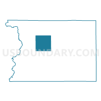
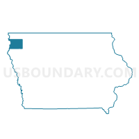
PLATO TWP Voting District, Sioux County, Iowa
About
Outline

Summary
| Unique Area Identifier | 583455 |
| Name | PLATO TWP Voting District |
| County | Sioux County |
| State | Iowa |
| Area (square miles) | 35.67 |
| Land Area (square miles) | 35.66 |
| Water Area (square miles) | 0.01 |
| % of Land Area | 99.97 |
| % of Water Area | 0.03 |
| Latitude of the Internal Point | 43.12557020 |
| Longtitude of the Internal Point | -96.27018290 |
Maps

Graphs
Select a template below for downloading or customizing gragh for PLATO TWP Voting District, Sioux County, Iowa


Neighbors
Neighoring Voting District (by Name) Neighboring Voting District on the Map
- CENTER TWP Voting District, Sioux County, IA
- EAGLE TWP Voting District, Sioux County, IA
- GARFIELD TWP Voting District, Sioux County, IA
- LINCOLN TWP Voting District, Sioux County, IA
- ROCK TWP Voting District, Sioux County, IA
- SIOUX TWP Voting District, Sioux County, IA
- WELCOME TWP W/O SIOUX CENTER Voting District, Sioux County, IA
- WEST BRANCH TWP PART W/O SIOUX CENTER Voting District, Sioux County, IA
Top 10 Neighboring County Subdivision (by Population) Neighboring County Subdivision on the Map
- West Branch township, Sioux County, IA (6,551)
- Rock township, Sioux County, IA (4,048)
- Lincoln township, Sioux County, IA (2,698)
- Welcome township, Sioux County, IA (1,730)
- Plato township, Sioux County, IA (505)
- Center township, Sioux County, IA (359)
- Sioux township, Sioux County, IA (339)
- Garfield township, Sioux County, IA (335)
- Eagle township, Sioux County, IA (283)
Top 10 Neighboring Unified School District (by Population) Neighboring Unified School District on the Map
- Sioux Center Community School District, IA (8,882)
- Rock Valley Community School District, IA (4,924)
- Boyden-Hull Community School District, IA (4,259)